
How to Successfully Sell a Plot of Land
Don’t sell only square metres
Two plots of 800 sq.m can have completely different value.
One may be flat, regulated, with asphalt access and utilities at the boundary.
The other may have a steep slope, difficult access and no nearby infrastructure.
On paper, the size is almost the same.
For the buyer, they are two completely different properties.
That is why size and price alone are not enough.
Show the location, not just the land itself
This is one of the most important parts of a land listing.
Too often, buyers see five or six nearly identical photos — grass, trees, a fence, more grass.
But what they really want to understand is:
How do you reach the property?
What is around it?
Are there houses nearby?
What does the road look like?
What is the view?
Is there infrastructure?
What does the wider area feel like?
If the buyer cannot clearly see the location, they cannot clearly see the value of the land.
For plots, photos of the surroundings can be almost as important as photos of the property itself.
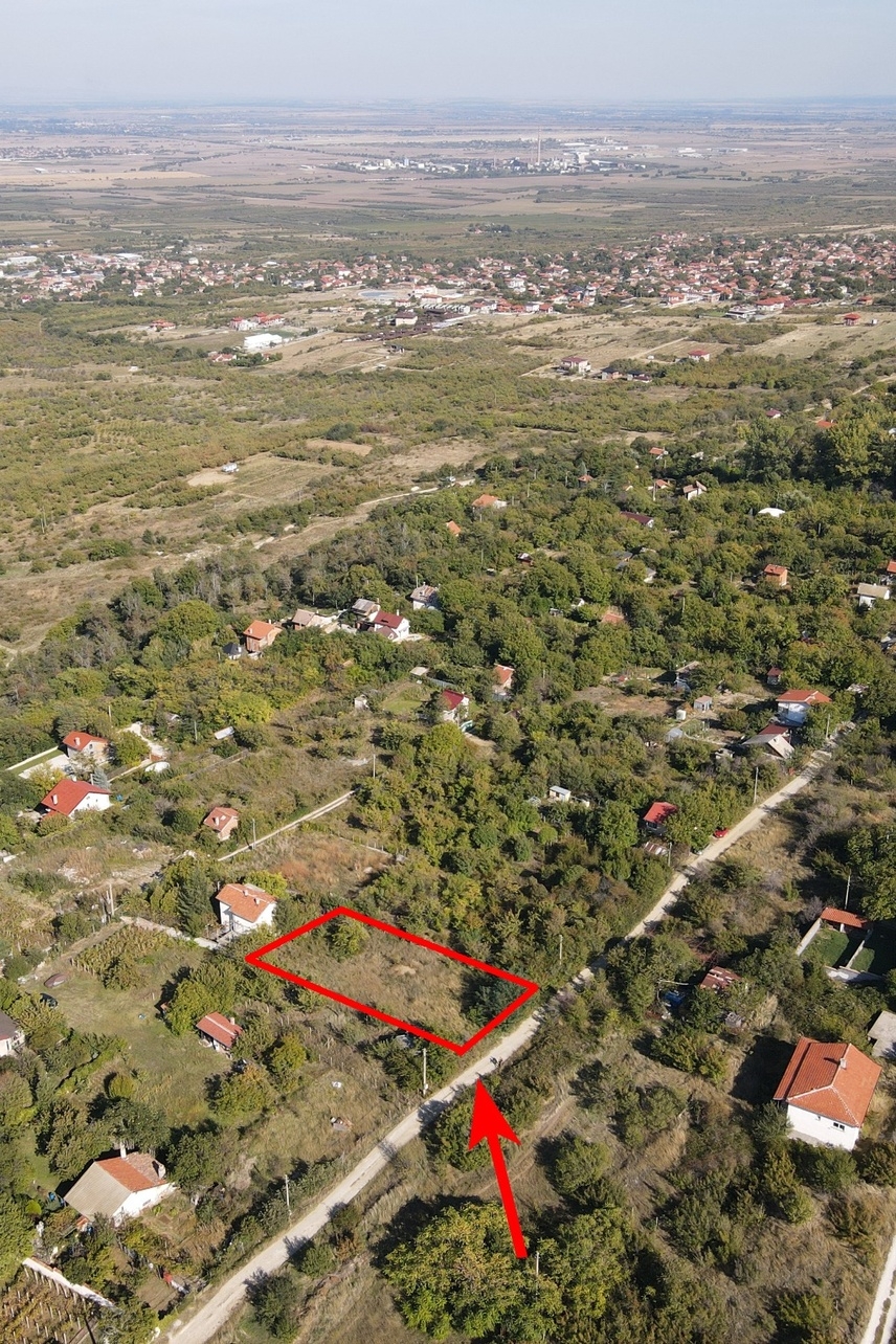
A drone photo can be the most informative image in the listing
Drone photography should not be used only to create a beautiful aerial shot.
For land, it can provide information that is difficult to understand from ground level.
A good drone image can show:
the entire plot;
its shape;
approximate boundaries;
access roads;
neighbouring properties;
nearby buildings;
infrastructure;
terrain;
proximity to the town or village.
It is even more useful when the boundaries of the plot are clearly marked on the aerial image.
This helps buyers understand immediately which part of the wider area is actually for sale.
If the marked outline is only for visual orientation and is not an official survey, this should be stated clearly.
Photograph the access to the property
Access can be one of the strongest advantages of a plot — or one of its biggest weaknesses.
So do not simply write:
“Good access.”
Show it.
Take a photo in the direction of the property and another looking back toward the main road.
If the asphalt reaches the plot itself, show that clearly.
Photograph the road frontage as well.
This tells the buyer much more than another close-up photo of the land.
The terrain should be visible
Photography can easily make a sloping plot look flatter than it really is.
But the gradient may affect both the future project and the construction budget.
Take photos from several positions.
If there is a slope, show it.
If the land is flat, show that too.
A good listing does not need to make everyone like the property.
It needs to give enough information for the right buyer to recognise that it suits them.
Property characteristics matter just as much as the photos
After the images comes the information.
A buyer should be able to quickly check the most important facts:
total area;
price and price per square metre;
planning or regulatory status;
land use;
building potential and development parameters, if known;
building permit, if available;
electricity;
water;
sewerage;
access;
road frontage;
terrain;
fencing;
orientation;
utilities;
nearby infrastructure.
Not every plot will have all of these features.
But information that is already known should not be left for a phone conversation.
This is where structured property listings are especially useful. On Dealehome, for example, key property characteristics can be entered separately from the free-text description, allowing buyers to understand the main parameters more quickly and use filters according to what they actually need.
This can be useful for both sides.
The buyer can quickly determine whether the land matches their criteria, while the seller may receive fewer calls from people who discover after the first question that the property is not suitable.
“Electricity and water nearby” is not enough
This is one of the most common phrases in land listings.
But “nearby” can mean many different things.
If you have more precise information, use it.
Is electricity already connected to the property?
Is it available at the boundary?
Where is the nearest transformer?
Is there a public water connection?
Is there an existing utility account?
Is there sewerage?
The same applies to building permits, planning status and other technical details.
Specific information creates far more trust than general claims.
Show the wider area
If the land has a beautiful view, include a separate photo of it.
If there are new houses nearby, show the surroundings.
If the property has quick access to a town or main road, a drone image can demonstrate this much more clearly than text alone.
Buyers are not choosing only coordinates on a map.
Especially when the land is intended for a future home, they are also choosing the environment in which they may live.
Don’t hide the disadvantages
If the last 300 metres are on an unpaved road, it is better for the buyer to know before the viewing.
If the land is sloped, show it.
If the area is still sparsely developed, present the real surroundings.
Hiding an obvious disadvantage may generate one more viewing.
But it is unlikely to produce the right buyer.
A good listing should not aim for the maximum number of viewings. It should aim for meaningful viewings.
Help the buyer imagine the future
This is the biggest difference between selling land and selling a finished home.
When someone views an apartment, they can already imagine living there.
With an empty plot, they need to picture the future house, garden, driveway and view from the terrace.
Your listing can help them do that.
Show the land from above.
Show the boundaries.
Show the road.
Show the view.
Show the surroundings.
And provide enough information for the buyer to understand not only what the plot looks like today, but also what it could become tomorrow.
Before publishing the listing
Open it as if you were seeing the property for the first time.
Ask yourself:
Do I understand exactly which plot is for sale?
Can I see how to access it?
Do I understand what is around it?
Can I see the slope and shape?
Do I know whether electricity and water are available?
Do I understand its legal and planning status?
Can I imagine what I could do with this property?
If the answer to several of these questions is “no,” the listing can probably still be improved.
Because land is not sold only through square metres. It is sold through information, location and a clear understanding of its potential.
Frequently Asked Questions
What photos should a good land listing include?
A strong listing should include general photos of the land, the access road, road frontage, surroundings, views and nearby infrastructure. Drone images are particularly useful because they show the full property and its location in context.
Should the boundaries be marked on a drone photo?
Yes, this can make the listing much easier to understand. If the outline is not based on an official survey, it should be clearly described as approximate or for orientation only.
What are the most important characteristics to include when selling land?
Important details include size, planning status, land use, access, road frontage, electricity, water, sewerage, terrain and building potential. If there is a valid building permit or other important documentation, this should also be mentioned.
Should disadvantages be shown in the listing?
Yes. Realistic presentation helps unsuitable buyers filter themselves out before arranging a viewing. This saves time and increases the likelihood that the people who contact the seller have genuine interest.


